City of Winnipeg Neighbourhood Profiles
Neighbourhood Profiles are available thanks to Statistics Canada and the Community Data Network, of which the City of Winnipeg is a member. The 2001 Census represents the most current socioeconomic information available.
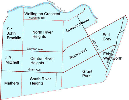
Click on the map to get information on a neighbourhood. Neighbourhood boundaries are indicated in red. Major streets are shown in black, unless they represent a neighbourhood boundary (shown in red).
◄ Back to Alphabetical Neighbourhood Listing

River Heights West Neighbourhood Cluster
River Heights West Neighbourhood Cluster.pdf
River Heights West Neighbourhood Cluster.xls
River Heights West Neighbourhoods
Central River Heights
Central River Heights.pdf
Central River Heights.xls
Crescentwood
Crescentwood.pdf
Crescentwood.xls
Earl Grey
Ebby-Wentworth
Ebby-Wentworth.pdf
Ebby-Wentworth.xls
Grant Park
J.B. Mitchell
J.B. Mitchell.pdf
J.B. Mitchell.xls
Mathers
North River Heights
North River Heights.pdf
North River Heights.xls
Rockwood
Sir John Franklin
Sir John Franklin.pdf
Sir John Franklin.xls
South River Heights
South River Heights.pdf
South River Heights.xls
Wellington Crescent
Wellington Crescent.pdf
Wellington Crescent.xls
* Top of Page
